Connect this guide with the rest of your visit in the Phuket trip planner. Read how the research is made and what its sources establish.
At a glance
Start here
- Use Karon Viewpoint to compare the shapes and development of Kata Noi, Kata and Karon bays.
- Use Promthep Cape to understand Phuket's southern edge and offshore orientation.
- Return in different conditions only when official access remains open; visibility is part of the landscape story.
- Stay within designated public areas and never cross a barrier for a photograph.
01
A viewpoint is a map with depth
A map flattens Phuket's bays and ridges; a high viewpoint restores their depth. TAT's Phuket page places the island in the Andaman Sea and names its major beaches, while the official day-route groups Karon Viewpoint with southern Phuket. Start by finding north, the nearest headland and the direction of open water.
Then compare what the map hid: the ridge separating bays, the curve of each beach, road cuts, building density and patches of vegetation. These are observations rather than rankings. The viewpoint becomes useful when a later journey along the coast can be connected to the landform seen from above.
- Find orientation before taking photographs.
- Trace the road rather than assuming straight-line travel.
- Compare natural edges with developed ones.
02
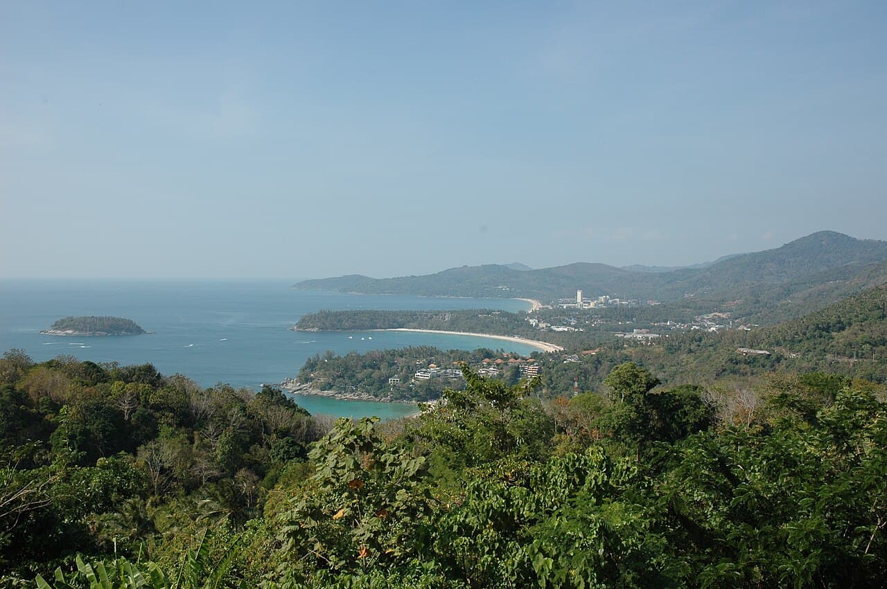
Karon Viewpoint shows how three bays differ
TAT's day-route identifies the scene from Karon Viewpoint as Kata Noi, Kata and Karon, three crescent-shaped bays visible from the summit area. The official attraction page confirms Karon Viewpoint as a current TAT-listed place, although its detail text did not render during this research. Use the day-route page for the substantive geographic claim.
Read from near to far. Compare the compactness of Kata Noi, the headland relationship around Kata and the longer line of Karon. Notice how ridges create visual separation even when roads link the districts. This explains why visiting several bays can take more time than their apparent proximity on a small map suggests.
- Name the bays in order before zooming the camera.
- Look for headlands that interrupt the shoreline.
- Do not infer swimming conditions from the elevated view.
03
Development patterns become visible from above
A viewpoint also shows where buildings gather: behind a beach, along a road corridor or on lower slopes. That pattern helps a visitor understand why neighbouring beach districts can feel different without reducing them to busy or quiet labels. Observe density, tree cover and the distance between water and built frontage.
Avoid turning visual impressions into population, ownership or environmental claims. A green patch is not automatically protected land, and an empty-looking bay is not necessarily undeveloped or publicly accessible. Use planning documents or responsible agencies for those conclusions. From the viewpoint, describe only the visible pattern and the questions it raises.
- Separate observation from explanation.
- Do not label land public or protected from appearance.
- Use the view to choose one district, not to rank them all.
04
Promthep Cape changes the orientation
The Phuket provincial capes page places Promthep at the island's southern end and describes views toward Ko Kaeo Phitsadan. TAT's Phuket route also pairs the cape with Karon Viewpoint. Moving from the three-bay view to the headland changes the question from how resorts occupy bays to how Phuket meets open sea and offshore islands.
The provincial page promotes sunset strongly, but a superlative is not necessary. The cape is useful in flat light, cloud or early in the day because its form remains visible. Do not chase a sunset by crossing barriers or using an unofficial path. Current signs and closures define the legitimate viewing area.
- Look back toward the island as well as out to sea.
- Identify offshore land only with a reliable map or sign.
- Accept poor visibility without moving beyond barriers.
05
Weather is part of the landscape reading
TMD's Southern West Coast forecast covers Phuket and publishes current rain, wind and wave information. Those values change, so none are reproduced as a standing claim. Before an exposed viewpoint visit, check the current regional forecast and any warning, then compare it with conditions and instructions at the site.
Haze, rain and low cloud can shorten the visible horizon, while strong wind or lightning can make an exposed stop inappropriate. This is not a cue to find an unsupervised alternative cliff. Replace the viewpoint with a museum, town walk or meal and return only when the relevant authority keeps access open. A forecast never guarantees safe footing.
- Check the short-range TMD page before setting out.
- Leave an exposed area when officials instruct visitors to do so.
- Do not use wave appearance from above to decide whether to swim or boat.
06
Make two views tell one story
A coherent viewpoint day needs only Karon and Promthep, with one optional ground-level stop between them. At Karon, study the sequence of west-coast bays. At Promthep, study the southern headland and offshore orientation. The travel between them then tests what was inferred about ridges, bends and settlement.
This sequence is an editorial comparison, not an access or driving promise. Verify both places on current official channels, set a return plan before waiting for evening, and drop the second stop if weather or transport weakens. The assigned Karon Viewpoint photograph directly matches the first landscape; it should not be captioned as Promthep Cape.
- Keep the photo caption tied to the actual pictured place.
- Choose one ground-level bay only if current conditions suit a land visit.
- End the day when the return plan becomes uncertain.
Useful answers
Reader questions
Which three bays are visible from Karon Viewpoint?
TAT's official route identifies Kata Noi, Kata and Karon. Use current signs at the viewpoint to orient the sequence on the day.
Sources: Tourism Authority of ThailandIs Promthep Cape only worth visiting at sunset?
No. Its headland form and offshore orientation can be read in other daylight conditions. Visibility, access and transport should matter more than chasing a particular photograph.
Sources: Phuket Provincial Governor's OfficeCan a clear viewpoint tell me a beach is safe for swimming?
No. An elevated view cannot establish currents, hazards or local restrictions. Current flags, lifeguards, authorities and official warnings must control any water decision.
Sources: Thai Meteorological Department; Tourism Authority of ThailandWhat if the TMD page shows storms or strong conditions?
Follow current warnings and avoid exposed stops when authorities advise it. Use an indoor alternative rather than seeking an unofficial cliff or assuming another coast is safe.
Sources: Thai Meteorological DepartmentRead the evidence
Sources and further reading
These sources support the relevant sections above. Plans and comparisons are editorial suggestions. Check operators for current arrangements.
- Phuket ↗Tourism Authority of Thailand · Research date 14 September 2026
Phuket's Andaman setting, named beach areas and general island geography.
- Recommended Route for One Day ↗Tourism Authority of Thailand · Research date 14 September 2026
Karon Viewpoint's view over Kata Noi, Kata and Karon and its official pairing with Promthep in southern Phuket.
- Karon Viewpoint ↗Tourism Authority of Thailand · Research date 14 September 2026
The current official attraction identity only; detailed page content did not render, so geographic claims use the separate TAT route page.
- Cape ↗Phuket Provincial Governor's Office · Research date 14 September 2026
Promthep Cape's southern headland setting and view toward Ko Kaeo Phitsadan; promotional superlatives are not repeated.
- Southern (West Coast) ↗Thai Meteorological Department · Research date 14 September 2026
The live official regional forecast channel covering Phuket; direct open timed out, so no mutable forecast values are asserted.